ICEYE Demonstrates Deployable ISR Cell with SAR Constellation at NATO Tiger Meet 2025
-
| Aerospace & UAV Researcher

At the NATO Tiger Meet 2025 in Finland, ICEYE demonstrated a rapidly deployable Intelligence, Surveillance and Reconnaissance (ISR) cell that integrates its Synthetic Aperture Radar (SAR) satellite constellation with tactical decision-making tools. The showcase marked a significant step in operationalizing commercial space-based ISR for frontline use by allied forces.
ICEYE’s Tactical ISR Cell Concept
The core of ICEYE’s demonstration was a modular ISR operations cell designed for rapid deployment and integration into coalition command structures. The system fuses real-time SAR satellite imagery from ICEYE’s constellation with mission planning software and situational awareness tools. Unlike traditional military satellite systems that may be constrained by bureaucratic tasking or limited revisit rates, ICEYE’s commercial model offers persistent monitoring—day/night and through cloud cover—with revisit times as low as several hours over key areas of interest.
The deployed cell included:
- Access to ICEYE’s proprietary SAR imagery via secure data links
- Integration with digital C2 systems for mission planning and BDA (battle damage assessment)
- On-site analysts capable of generating actionable intelligence within minutes of image acquisition
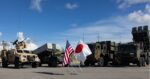
- A mobile command post setup compatible with NATO-standard communications protocols
This modular architecture allows the system to be fielded near operational theaters or embedded within multinational HQs to support time-sensitive targeting and dynamic mission updates.
SAR Imagery for All-Weather Tactical Awareness
Synthetic Aperture Radar remains one of the few remote sensing technologies capable of delivering high-resolution imagery regardless of weather or lighting conditions. ICEYE’s satellites operate in X-band frequencies (~9.65 GHz), which offer a balance between resolution and penetration through atmospheric obscurants like clouds or smoke—critical in contested environments where EO/IR sensors are degraded.
Each ICEYE satellite is capable of imaging at resolutions down to 0.25 meters in spotlight mode and can cover swaths up to hundreds of square kilometers in stripmap mode. This flexibility enables both wide-area surveillance and focused monitoring of high-value targets such as airfields, artillery positions, or logistics nodes.
During the NATO Tiger Meet exercise scenario—a simulated multi-domain conflict involving air-ground coordination—ICEYE’s cell provided persistent overwatch over designated red force areas. Analysts were able to detect changes in terrain features (e.g., vehicle tracks), identify decoys versus actual assets using coherent change detection (CCD), and cue air assets accordingly.
Tactical Integration with Air and Ground Forces
The key innovation was not just the imagery itself but how it was fused into operational workflows. ICEYE partnered with Finnish defense integrators to link its data feeds into existing C4ISR platforms used by participating NATO units at the exercise. This included compatibility with Link-16 terminals for cueing fighter aircraft and integration into Joint Terminal Attack Controller (JTAC) tablets used on the ground.
According to company officials present at the event, turnaround times from image collection to dissemination averaged under 15 minutes—a significant improvement over legacy national-level tasking systems that often suffer from latency measured in hours or days.
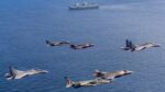
This rapid cycle enabled real-time targeting updates during close air support missions flown by participating squadrons such as France’s EC 3/11 “Corse” Mirage 2000D unit and Portugal’s F-16AM detachment.
Commercial Constellations Filling Military Gaps
The demonstration underscores a growing trend: leveraging commercial space capabilities to augment military ISR capacity without requiring sovereign satellite infrastructure. With over two dozen satellites currently on orbit—and plans for expansion—ICEYE offers revisit rates competitive with some national systems but without their bureaucratic overheads.
This is particularly relevant for smaller NATO members who lack dedicated space assets but require timely geospatial intelligence for border monitoring, target development, or disaster response. Through secure subscription models or direct government partnerships (e.g., Finland’s Ministry of Defence has an ongoing agreement with ICEYE), allied forces can access responsive tasking without waiting on strategic-level approvals.
Additionally, commercial players like ICEYE are increasingly compliant with defense-grade cybersecurity standards (e.g., ISO/IEC 27001) and are building APIs compatible with NATO Federated Mission Networking (FMN) architectures—a prerequisite for seamless integration into joint operations.
NATO Interest in Responsive Space-Based ISR
NATO has been actively exploring ways to integrate commercial space services into its evolving Multi-Domain Operations (MDO) doctrine. The Allied Command Transformation (ACT) has launched several initiatives under its Innovation Hub umbrella aimed at evaluating persistent surveillance using LEO constellations—including radar imaging platforms like ICEYE alongside optical providers such as Capella Space or Planet Labs.
The Tiger Meet demonstration provided practical validation that these capabilities can be fielded tactically—not just at strategic echelons—and deliver measurable effects on kill chains involving air-ground coordination under contested electromagnetic environments.
A senior officer from the Finnish Air Force noted during post-exercise briefings that “the ability to receive fresh radar imagery directly into our mission planning tools while jets are still on alert status changes how we think about pre-strike intelligence.”
Future Directions: AI Fusion and Maritime Applications
Looking ahead, ICEYE is investing heavily in onboard processing capabilities—including AI-driven object detection algorithms—to reduce bandwidth requirements and accelerate decision cycles even further. Future iterations may also include cross-cueing between radar satellites and EO/IR drones or High-Altitude Pseudo Satellites (HAPS).
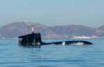
The company is also expanding maritime applications beyond traditional ship tracking via AIS spoofing detection—using radar signatures alone to identify vessels operating dark. This has implications not only for naval operations but also sanctions enforcement missions led by EU/NATO partners in regions like the Black Sea or Eastern Mediterranean.
Conclusion: Commercial SAR Goes Tactical
The deployment of an operational ISR cell by ICEYE at NATO Tiger Meet 2025 marks a milestone in democratizing access to advanced geospatial intelligence across alliance members. By combining persistent radar coverage from LEO satellites with agile ground processing nodes integrated into C4ISR networks, commercial providers are now enabling tactical commanders—not just national agencies—to benefit from space-based surveillance in near-real time.